Sometimes when the gps has a lack of energy, and when navigation in areas with highly variable depth, including an high presence of submerged rocks or close to the surface, all sprinkled with a large tidal range, it is important to know how to avoid the dangers. It is always best to know where we are not rather than don't know where we are!
1)Marks
To find our position on the water we will use mostly visible marks, noticeable(avoid as much as possible buoys, moving around their chain origin) and clearly identifiable, landmarks and seamarks(for example lighthouses, poles, chimneys…), and sounder. Marks chosen must be noticeable on the chart and especially not taken for an another(careful when you choose a water tower…better to avoid when there are plenty in the area). In non-tidal waters sounder allows us to directly write our position on the map with the lines of sounding, with tide must be aware of the calculation of the tide and add it up with sounder informations.
2)Tools
With the help of these marks and sounder we will be able to find our position on a point or an area of the water, there are several tools for that, I have classified them from the more accurate to the less accurate.
Two transits: when two transits of two marks each observed simultaneously. It is rare, but we can then draw on the chart our position easily(at 14:15 when the two transits can be seen, we can have our position very precisely).
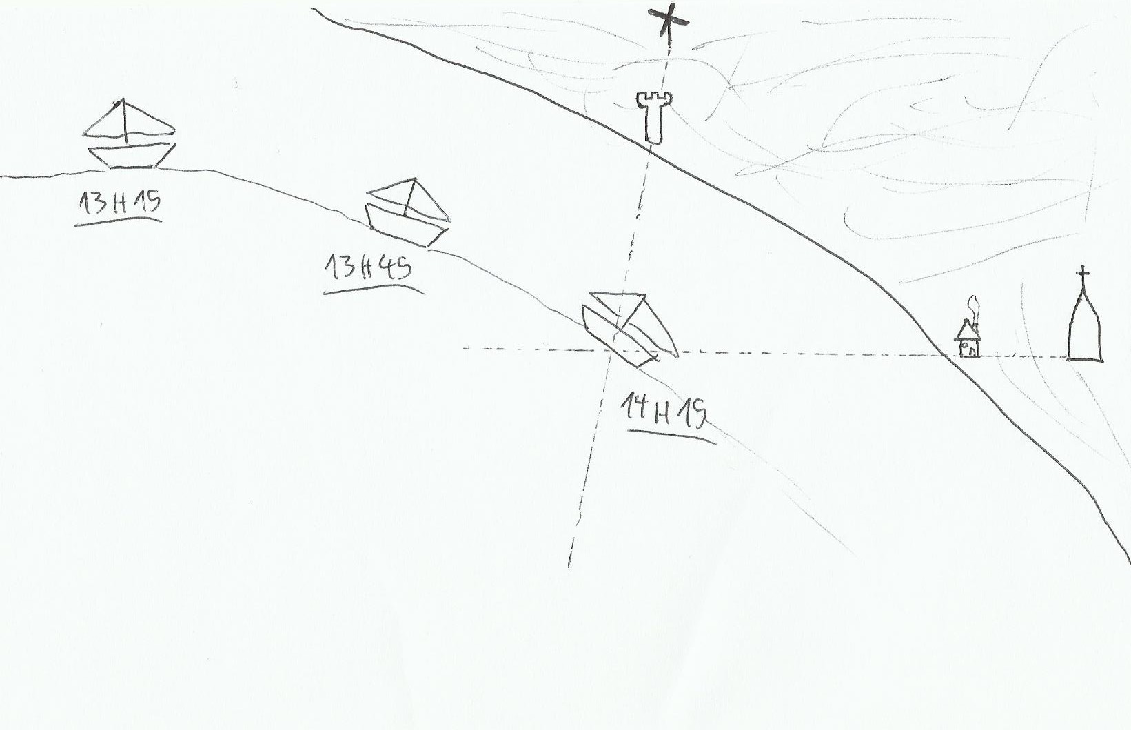
A transit and a line of sounding: in this case, a transit of two marks is noticed, and at the same time the sounder indicates a passage on an easily recognizable depth on the chart.
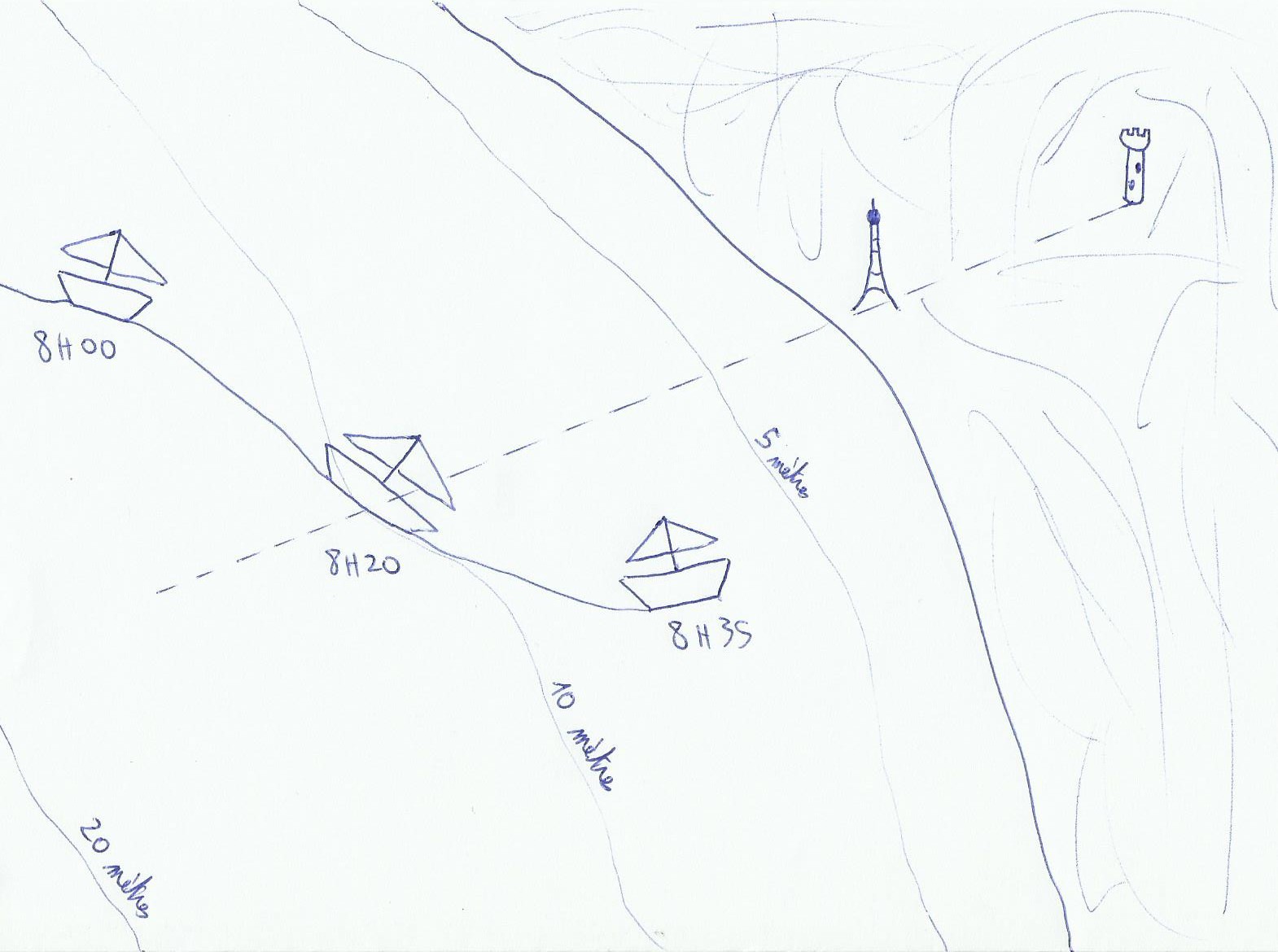
at 8:20 am, sounder tells us 10 meters, position is known(in tidal waters don't forget the tidal range!).
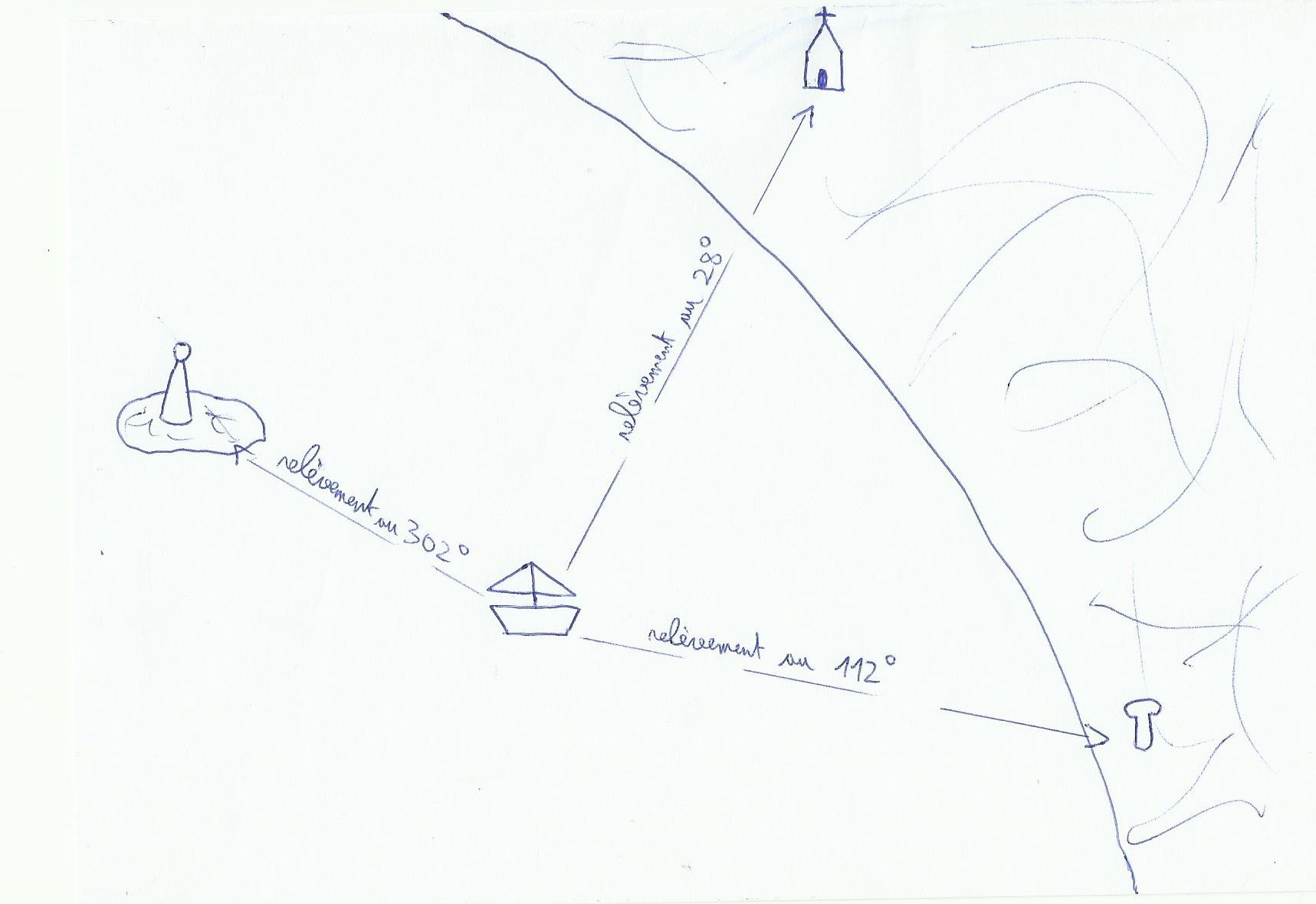
A range and a bearing: this time we will use the hand bearing compass. For example we are following a range(so it is a running range called a leading line too)and we notice an isolated landmark on starboard, northward of us precisely.
A point with three bearings: the more the three landmarks are spaced(in the best case, 120° between each landmark, then it's Christmas time!)the more the point will be more accurate. The lines of the three compass bearings on the chart is joined at best on a single point(rare), if in general it forms a triangle positioning called cocked hat, we live somewhere in this triangle(. To check the truth of the point we can take a look on the sounder.
2)Avoid hazardous areas
Transit: we say that a range is opened right when the farthest mark is on the right hand of the closest mark, if it is left open, it is left hand. When we talk about open range, this is not a steering range but a safety range. In fact in this case when it's close, he tells us we have crossed a safety line to go into a dangerous area. we will have to move.

In zone A, which is without danger the range is open right. Approaching the area B it will close itself gradually.
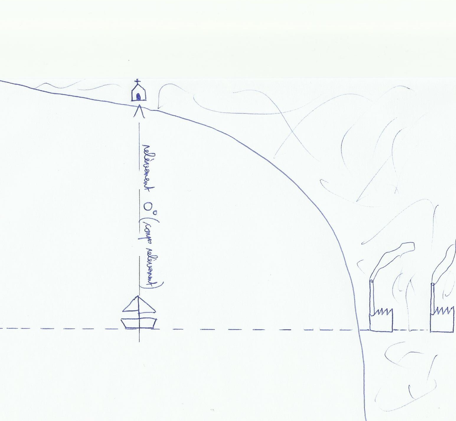
compass bearing: a compass bearing is sometimes useful to avoid a dangerous area.
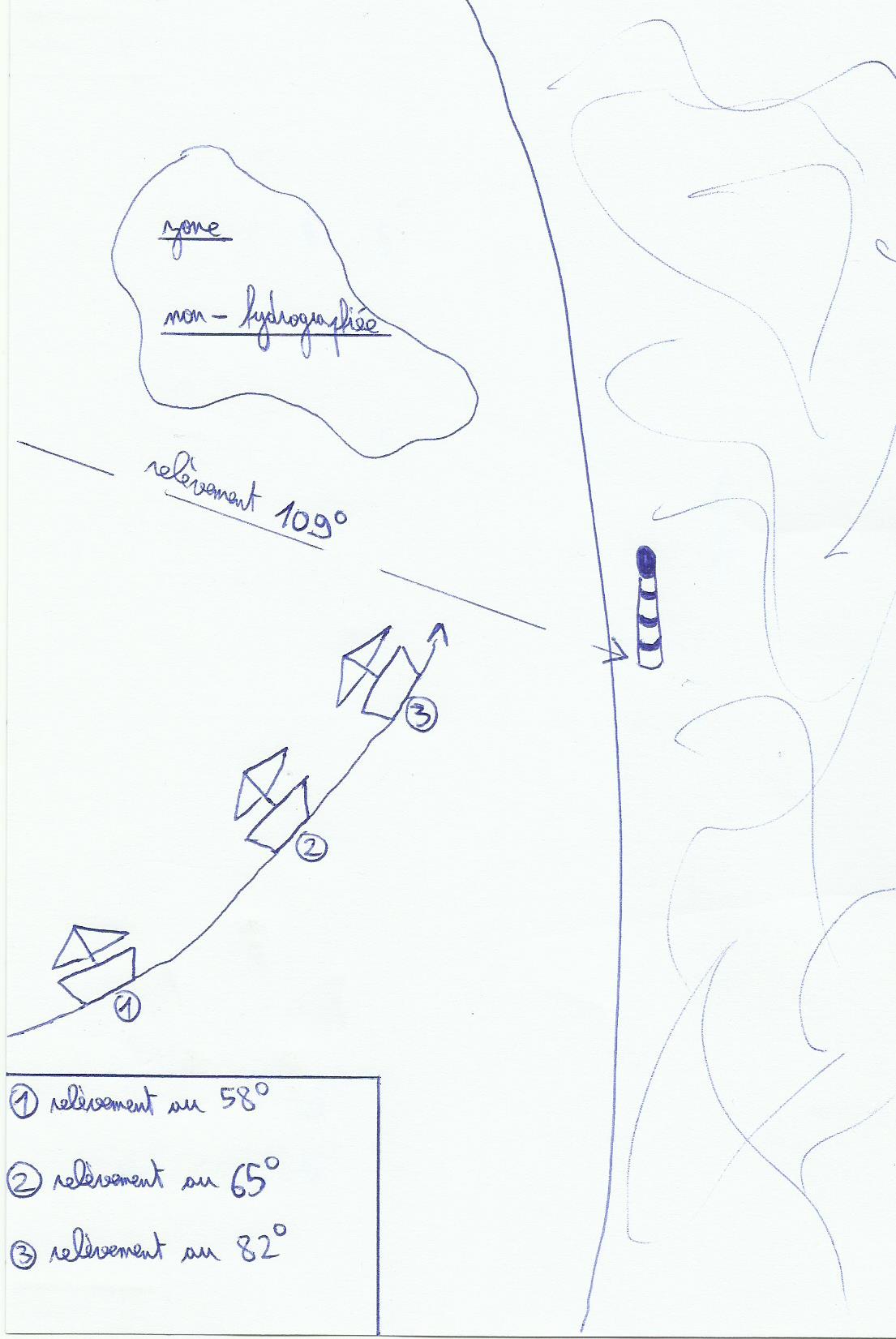
We foresee a little safety margin, it gives us a bearing of 109 °. It means that if the compass bearing exceeds 109 °, we are too far northward of it(the mark we have used), So we are in the non-hydrographiée area.
Sounding: The sounder can allow us to avoid a hazard if it is surrounded by a clear sounding line and significant enough away from it.

A 15 hours we know that we enters in the area between 20 and 10 meters.
If there is no sounding line around the dangers for example around a lighthouse, an island or an isolated mark, you can use the height of the danger(if it's written on the chart), lighthouse or mark in question:

In fact we will just use old(and boring) Pythagore rules learnt at school, finally it's sometimes usefull! If we forget 1852 in the calculations distance away from the mark is given in meters. Knowing that the tip of the index makes roughly an angle of 0.5 ° when the arm is extended on the sky, so we are able to find the alpha angle without the help of sextant. A lighthouse of 25 meters of height hidden by 4 fingers provides an alpha angle of approximately 2 °, it means that we are approximately at a distance of 720 meters from the lighthouse. A lighthouse of 30 meters seen at 2 ° gives a separation distance of 860 meters roughly.
3)Useful tricks
Compass bearings: when the hand bearing compass is used, it must be not surrounded by any electronic device(less than 1 meter roughly)(speakers, electromagnetic things…)or cables which may affect the magnetism, and at the same time informations on our compass. you have to keep in your mind that the more rough the sea is, the more the result of the measurement will be inaccurate, and between the compass bearing and the line drawn on the chart, the boat will keep its way, so unfortunately the information transcribed on the chart will not be "live"…To draw a bearing on the chart the most of time we consider the variation only(true bearing compass=bearing compass variation + declination).
For an accurate cocked hat, we will take the bearings of the three landmarks in a specific order. D & rsquo; first one who moves the least with respect to the direction and speed of the boat(l & rsquo; most bitter on & rsquo; back), then the one that is more abow, and finally the most through. The center of the gravity circle of the triangle's cocked hat is considered as our position.
Transits, or marks search: if marks sought are located between the sun and the observer(by delighted and clear weather), it is very difficult to identify them. If the chart indicates a steering range to follow and we are not sure about marks noticed on the landscape, if we have them in line and in the same time watched beyond the hand bearing compass we are able to know then if it's okay or not with the data of our chart. For an accurate transit the closest mark must be downer than the other one, to have a visible sight .
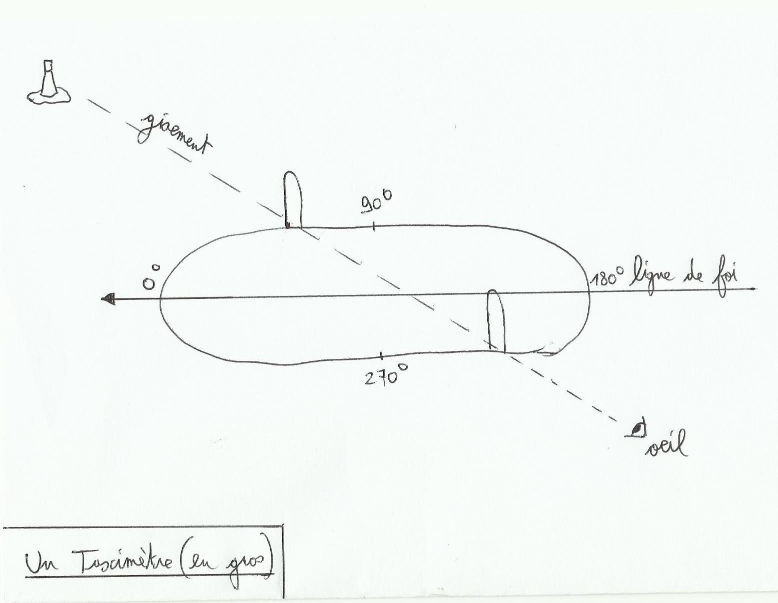
Relative bearing: sometimes when you're too lazy to use the hand bearing compass, or when it was dropped in water, we can cope without it with this method. The relative bearing is the angle between the mark and the bow of the boat. In fact True bearing compass=true heading relative bearing + nothing. To find the relative bearing it is possible to establish benchmarks around the boat, each giving you a defined angle. You can also install a taximeter.
The taximeter is an instrument fixed at the center of the highest place aboard, its axis is the length line of the vessel and an alidade(like a sextant)is used for angular measurements.
you note : “For an accurate cocked hat, we will take the bearings of the three landmarks in a specific order. In the first time we choose the one which is moving the most in comparison to us(the mark the most abeam)”. No ! it's the contrary ! must take the most bitter autravers “last, just before going to the chart table” because it is actually the one who moves the most. Donc il faut le temps minimum entre sa prise et son positionnement sur la carte 🙂
ha so thin I was wrong! Although seen thank you!
So I change my dumpling neither seen nor known