The meridian is easy to implement and does not require a lot of calculations, however the summer line of position can become a big mess with a forbidden step or a mistake. But this method has an advantage on the meridian: we can guess our position at any time of the day, we have just to make two observations of the sun's height(at least two hours of gap for accuracy). In case of overcast sky, the summer line's method is the only choice if at local noon the sun is hidden by clouds.
1)Main idea
Measuring a height of the sun at any time of the day puts us on a circle on the globe's surface:
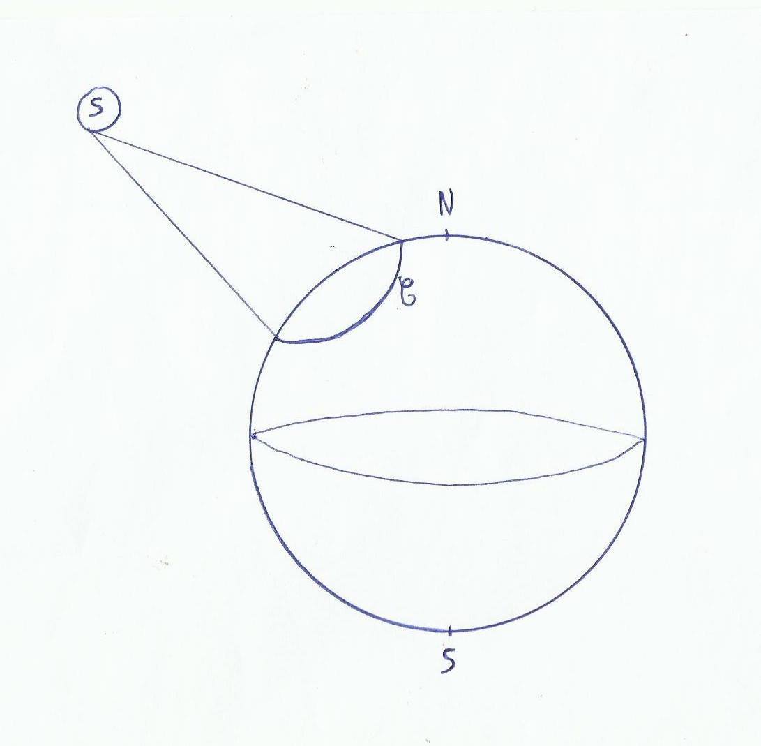
This circle called C, by the time we are on it show us the sun under a specific height. This height is called calculated height(Hc) it's calculated, it depends on our position(which we estimate, for example by taking as estimated point the last written in the logbook)and the time of day(the foot of the star will not have the same position)when we have caught Hv . Then we compare Hc and Hv, the true height is measured by the sextant(Hv). If Hv>Hc, then reports the point to the sun, otherwise the inverse. The difference between Hv and Hc is called intercept.
For the summer line there are borderline cases:
20°<Hv<80°
Intercept<30 Miles
-60°<observation's latitude<60°
On the chart, Circle C where we see the sun on the calculated height is drawn as a straight line because on the globe it's a very large circle, reducible on a chart with a lower scale. The real circle where we are(where the sun is observed with the true height Hv)is fund with intercept we call it C2. C2 is also drawn like a straight line, it is the summer line of position.
I is the intercept, in fact it is a tranfer's line. If Hv>Hc, we translate the C line on the other direction of the sun in the form of the C2 line, otherwise the inverse. In practice we do not draw C, the intercept is drawn from the estimated point on the chart.
So for a single observation / measurement of the height of the sun at any time of the day, we can position ourselves on a straight line only. To have a position in latitude / longitude a second observation is required. When we have drawn the second straight line found we will have to translate C2 according to our distance over ground between our observations, final intersection give us our position at the time of the second observation.
2)Matter's heart
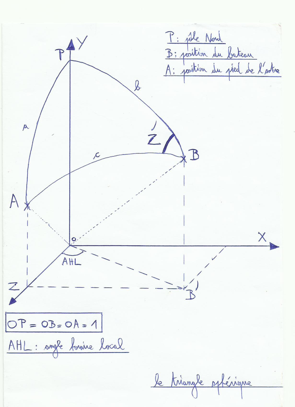
The calculation of Hc requires a little trigonometry(see "trigo") and a hint of scalar calculations, it is more suitable to keep the formula in a programmable calculator like TI89 . Otherwise the method to find it is the following: Considering the earth as a sphere of radius 1, and included in a Cartesian coordinate system where the origin is the center of this sphere(ho no, do not turn on the GPS yet it's gone a be ok!). B is our estimated position, A is the position of the star's foot when Hv has been caught, P is the North Pole.
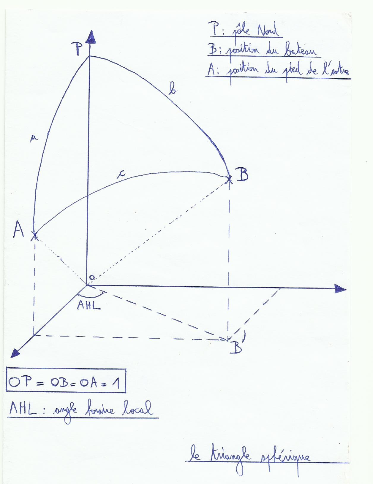
Three spherical segments are got, a b and c. a=90°-D(declination of the sun at the time of Hv measurement), b=90°-Le(Latitude of our estimated point), c=90°-Hc.
AHL = AHG-G(Hour Angle of the Sun, angle between the foot of the sun and Greenwich horary circle, and we subtract the longitude of our estimated point, in fact AHL is the angle between sun's foot meridian and estimated point's meridian).
The purpose will be to put it all into an equation to determine Hc. For this we will make a scalar multiplication of 0A and OB vectors(pfffiouuuuu…..).
We will use our Cartesian coordinate system to define these vectors.
0A: On the X axis, OA = 0. On the Y axis, OA = sin(a) and Z-axis OA = cos(a).
0B: On the X axis, OB=sin(b)*sin(AHL), on Y-axis OB=sin(b)*cos(AHL) and axis Z OB = cos(b).
The scalar product of two vectors in a Cartesian coordinate system is done by multiplying their coordinates and add them, so OA(X,Y,Z) and OB(X’,Y ',Z '):
XX’ YY’ ZZ’=0 sin(a)*sin(b)*cos(AHL)+cos(a)*cos(b)
We also find the scalar product by multiplying the vectors length by the cosine of the angle between them(don't forget that OB = 0A = 1):
OA*OB*cos(c)= 1 * 1 * cos(c)= Cos(c)
Conclusion: cos(c)= sin(a)*sin(b)*cos(AHL)+cos(a)*cos(b), so:
cos(90°-Hc)= sin(90°-D)*sin(90°-Le)*cos(AHL)+cos(90°-D)*cos(90°-Le), so:
sin(Hc)= Cos(D)*cos(the )*cos(AHL)+sin(D)*sin(the )
That's why it is better to note the formula directly somewhere…do that on the chart table in rough sea, after having eaten a good heavy meal, it can become a bit difficult!
Troubles are not over, we have Hv, Hc so we have our intercept. It's nice, but how to draw our line C on the chart? something is missing, azimuth. The azimuth is the angle between the noth pole's vertical and the sun's vertical. we call it Z(basically it's the exact bearing of the sun relative to our place of observation). To find it first calculates Z '.
To find Z angle’ we take the formula seen before(circular permutation formula, I don't know the name in English i'm not sure sorry): cos(c)= sin(a)*sin(b)*cos(AHL)+cos(a)*cos(b). What interests us is the angle Z ', so: cos(a)= sin(b)*sin(c)*cos(Z ')+cos(c)*cos(b)
so, cos(90-D)= sin(90-the )*sin(90-Hc)*cos(Z ')+cos(90-Hc)*cos(90-the ), and now:
sin(D)= Cos(the )*cos(Hc)*cos(Z ')+sin(Hc)*sin(the ) and at the end cos(Z ')=(sin(D)-sin(the )*sin(Hc))/(cos(the )*cos(Hc))
Once Z’ determined, to find Z(true azimuth, , the sun's bearing calculated )it's simple:
Z = Z’ if it is morning(if the sun is on the East), and Z = 360 °-Z’ if it is after noon(if the sun is in the West).
Once we have the intercept and azimuth, then we are able to draw our summer line of position from our estimated point. The azimuth which is the calculated sun's bearing give us direction to draw intercept(intercept will be perpendicular to the summer line of position), the intercept gives us the distance between the summer line and the estimated point, and also the right side to draw summer line compared with estimated point(towards the sun, away from the sun).
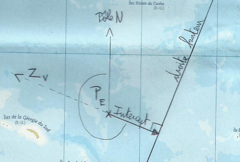
In the example, Pe is the estimated starting point, Zv is the true azimuth. In this case Hv<Hc, so the intercept is on the opposite side of the sun.
The best method for this is to have a programmable calculator instrument texas like(TI89 it's efficient), for a time the almanac included a Breton sailor sheet program to return to the calculator handy and despite a couple of errors to be corrected. , I think there are also astro Special calculators designed for that. The Breton sailor book explains very well this method.