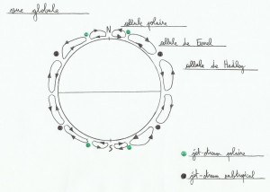
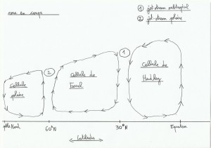
Low pressure systems in temperate areas come mainly from polar jet stream, it confronts the movement of the cold air mass of the polar cell and the heat of the Ferrel cell air mass.
Convective cells work much like big pinion gears, hot air climbs, when it's rising it's getting colder, the more it's cool the more it's dense, so it becomes heavier and falls. If the earth were smaller there would be less of convective cells.
The polar jet stream is stronger and lower in altitude compared to subtropical jet stream. The Jet Stream follows roughly a circular path around the globe, bringing strong westerly winds at this location.
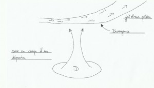
The polar jet stream does not blow at a constant strenght, doesn't go on straight so it's not steady. It changes its speed according to its corners or meanders like a river, causing crowding or air dispersion depending on location. When there is overcrowding we are talking about convergence(the air gets off to the surface), and dispersion is called divergence(it creates air calls from the surface). These two cases are the source of cold and warm fronts met in a low pressure system.
Low pressure systems changes and moves in time, in the northern hemisphere they are mostly born close to American shores in the western Atlantic, grown on ocean and finish their lives in Northern Europe or the eastern Mediterranean.
1)Low pressure ingredients
According to Buys Ballot 's law, we know that the wind is turning anticlockwise around LPS in the northern hemisphere(contrary in the South).
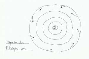 In altitude wind follows the isobaric lines(lines of equal atmospheric pressure)and with the friction on surface, wind enters in LPS forming an angle of approximately 20 ° with the isobaric lines. With a larger friction(On earth with mountains for example)this angle will increase.
A LPS on its side:
jet stream's divergence creates an air call from the surface.
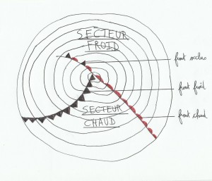
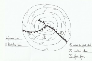
An another LPS's feature, it is the presence of fronts inside. There are two kinds of fronts, warm front and cold front, and two areas called cold sector and warm sector(because LPS is nothing more than a meeting between a stream of cold air and a stream of hot air under Coriolis influence). For LPS more “matures” we find an occluded front and a triple point too.
On the weather forecast's maps warm fronts are red and cold fronts are blue(I have lost my blue pen…), they are symbolized like this draw on the right. The triple point is the meeting point of fronts.
When a LPS grows, at the beginning there is no occluded front and warm and cold fronts are wide apart. With time, the cold front (which is fastest) overtakes the warm front creating the occluded front which increases progressively as the warm sector is overtaken, and the triple point is shifted more and more with the center of the depression. The more LPS gets older and more fronts will turn into LPS in the same direction as the wind.
Occluded front: when the cold air mass has overtaken the hot air mass, the lighter warm air was ejected in altitude. These fronts are generally characterized by a very overcast sky and rain, less windy.
Cold front: when cold air ejects warm air aloft, this leads to unstable wind and visibility conditions . This is generally the place where the wind is stronger with presence of squalls in a LPS.
Warm front: Here the warm air rises gently above the cold air, causing a gradual increase in cloud cover.
2)Clouds met
Different types of clouds are found in LPS depending on where you are inside, and the barometer is also a precious tool to locate yourself inside.
1. Warm front arrival: first we can see cirrus(high clouds with a hair shape, filaments)with a decrease of the atmospheric pressure. With more cirrus “curved” there is more chances to see the situation deteriorate rapidly. For the moment the weather is still clear with good visibility. Followed by cirrostratus(still in altitude), clouds formed by ice particles look like white veins, the only one able to produce a halo around the sun or moon. If halo decreases, it is a sign of rain, Check the warm sector. At this point the pressure is further reduced and the visibility decreases.
2. Warm sector: cloud cover goes down and grow, pressure still decreases. Just before the warm front we see altostratus(greyish veil through which the sun or moon may appear as a blur disk)the sky is darken. The warm front brings stabilization of the atmospheric pressure and a low, dark cloud cover with rain(stratus, nimbostratus). In the warm sector, we find stratus which are the lowest clouds, making a uniform veil; pressure is still stable and visibility is low. Usually in the warm sector winds come from the west or south-west(Northern Hemisphere).
3. Cold front: Cold front arrival brings a slight decrease followed by an increase in atmospheric pressure. cloud cover which is still thick rub out a little, squalls come. At the cold front we notice the cumulonimbus presence(very extensive vertical clouds, source of strong wind and gusts), a rapid rise in pressure and a better visibility however reduced under squalls. At the cold front there is also mostly a wind shift to the Northwest.
3)LPS life
Youth: fronts are setting up, the pressure decreases and the angle between fronts is very wide. LPS center is superimposed with the triple point, rain appears close to the fronts.
Maturity: LPS moves faster(between 15 and 40 knots roughly), the cold front begins to overtake the warm front creating the occluded front, and the triple point separates from the center of the depression. The wind gets stronger under the cold front, and shows a significant changes about wind direction.
Ageing: Significant occlusion with the approach of the coast, LPS center slows or stops. Rainfalls increase under occlusion and the wind is less strong, the wind shift at the cold front is less significant.
End: the fronts are no longer differentiated each other, LPS doesn't move anymore and fronts still turn around LPS center with its heads down.
4)Cross wind rule
This convenient and effective rule is a little asset to locate yourself in a LPS, it provides clues to guess upcoming weather(here, Northern Hemisphere).
You are in face with the surface wind. With altitude winds(indicated by the high clouds, cirrus eg), you may grab clues about LPS motions:
.If the altitude winds are coming from the right, the warm front is coming.
.If they are coming from the left, LPS is going away.
.If surface / altitude winds are parallel, or almost parallels around some degrees of course, and in the same direction we are in the warm sector(but generally in the warm sector we can not see the high clouds, we know that we are here with steady pressure and dense cloud cover, low and rotten…).
.If it's parallel and opposite, you are in the cold sector, LPS north.
Notice: A west residual swell may also be an another clue for a LPS arrival.
There are plenty of books that explain very well LPS as “weather and strategy, cruising and racing” de Jean-Yves Bernot, navy block is not bad too.
