Low pressure systems

Low pressure systems in temperate areas come mainly from polar jet stream, it confronts the movement of the cold air mass of the polar cell and the heat of the Ferrel cell air mass.

depression

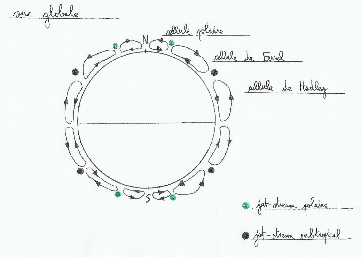
Convective cells work much like big pinion gears, hot air climbs, when it's rising it's getting colder, the more it's cool the more it's dense, so it becomes heavier and falls. If the earth were smaller there would be less of convective cells.


depression.2

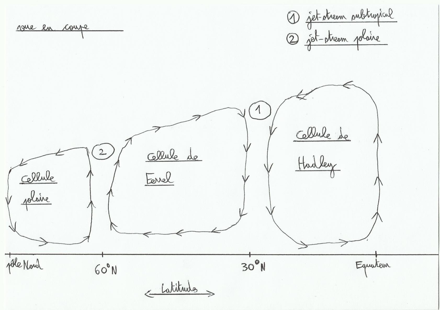
The polar jet stream is stronger and lower in altitude compared to subtropical jet stream. The Jet Stream follows roughly a circular path around the globe, bringing strong westerly winds at this location.


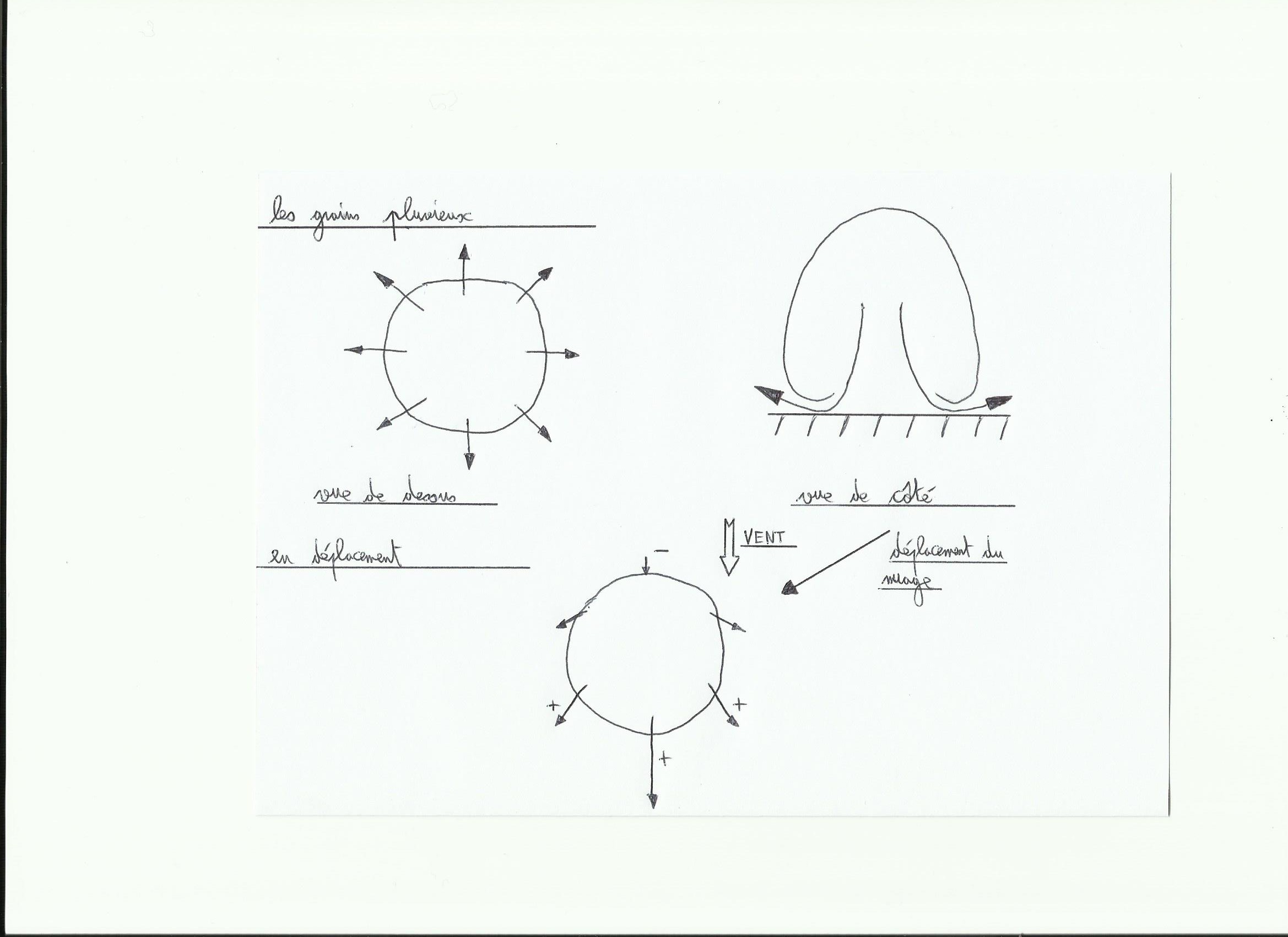
The polar jet stream does not blow at a constant strenght, doesn't go on straight so it's not steady. It changes its speed according to its corners or meanders like a river, causing crowding or air dispersion depending on location. When there is overcrowding we are talking about convergence(the air gets off to the surface), and dispersion is called divergence(it creates air calls from the surface). These two cases are the source of cold and warm fronts met in a low pressure system.

Low pressure systems changes and moves in time, in the northern hemisphere they are mostly born close to American shores in the western Atlantic, grown on ocean and finish their lives in Northern Europe or the eastern Mediterranean.

1)Low pressure ingredients

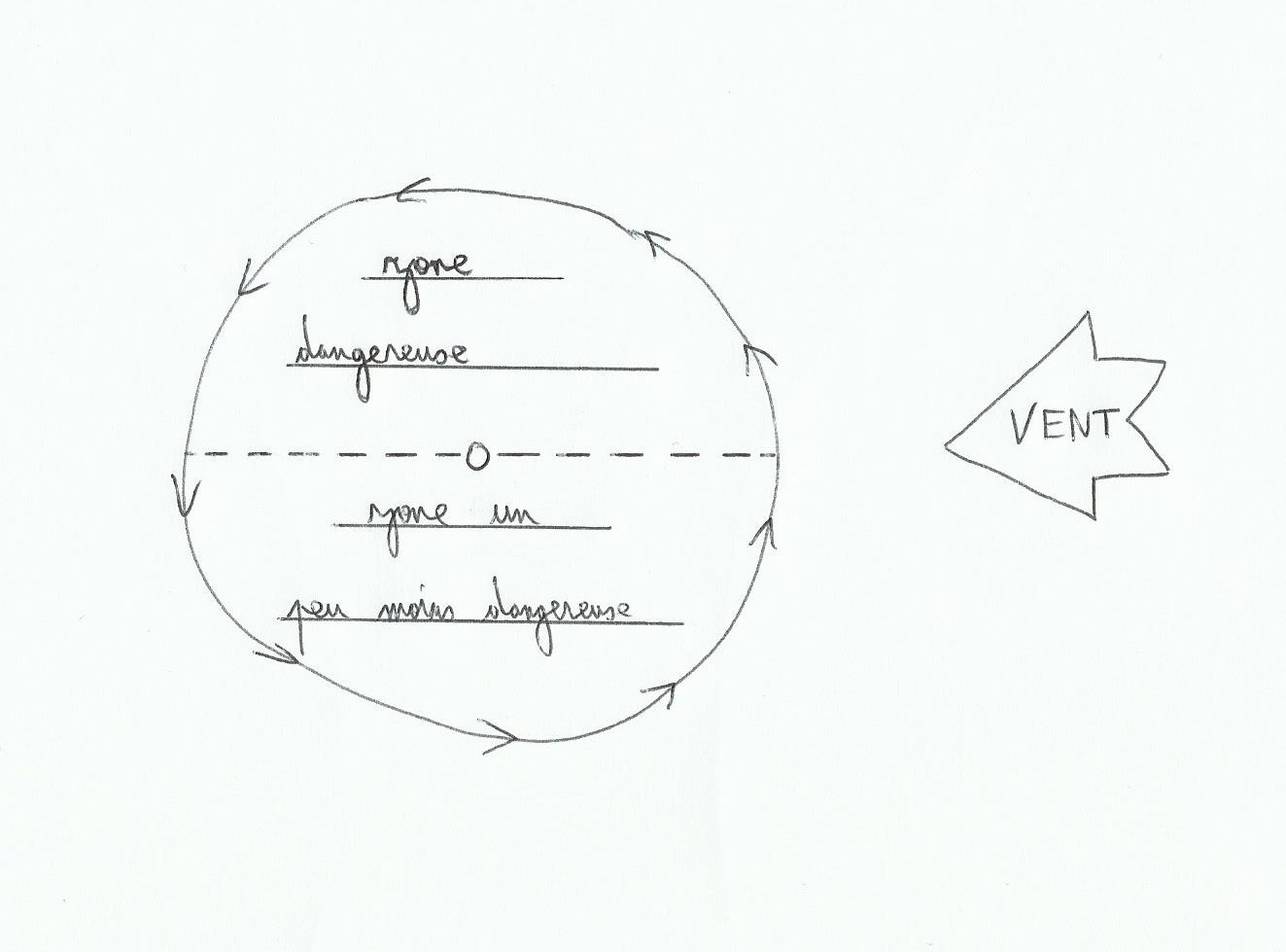
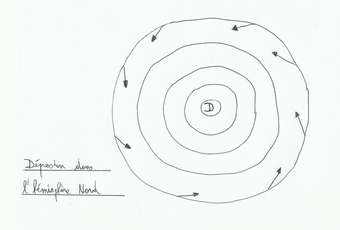
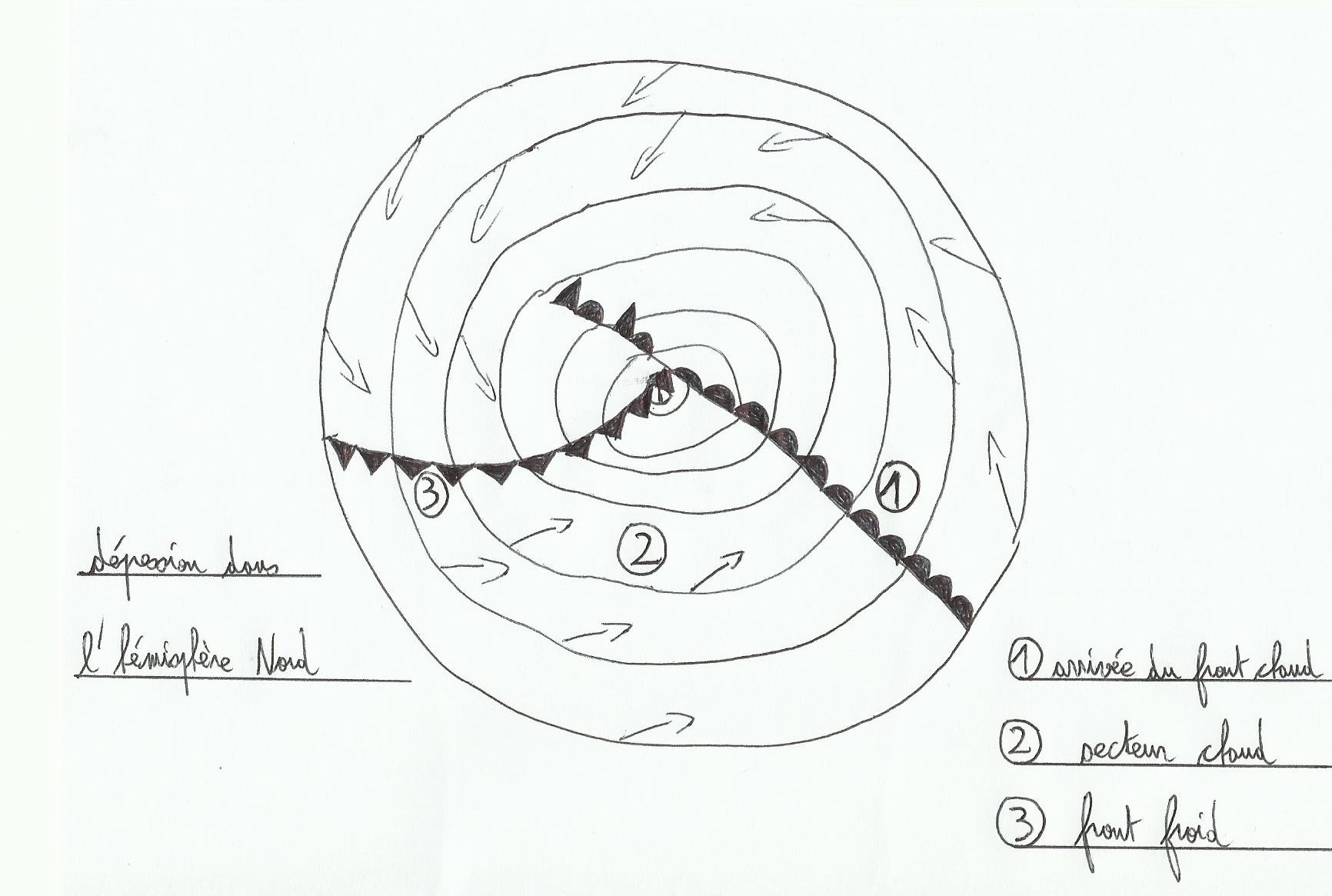
According to Buys Ballot 's law, we know that the wind is turning anticlockwise around LPS in the northern hemisphere(contrary in the South).

dépression3
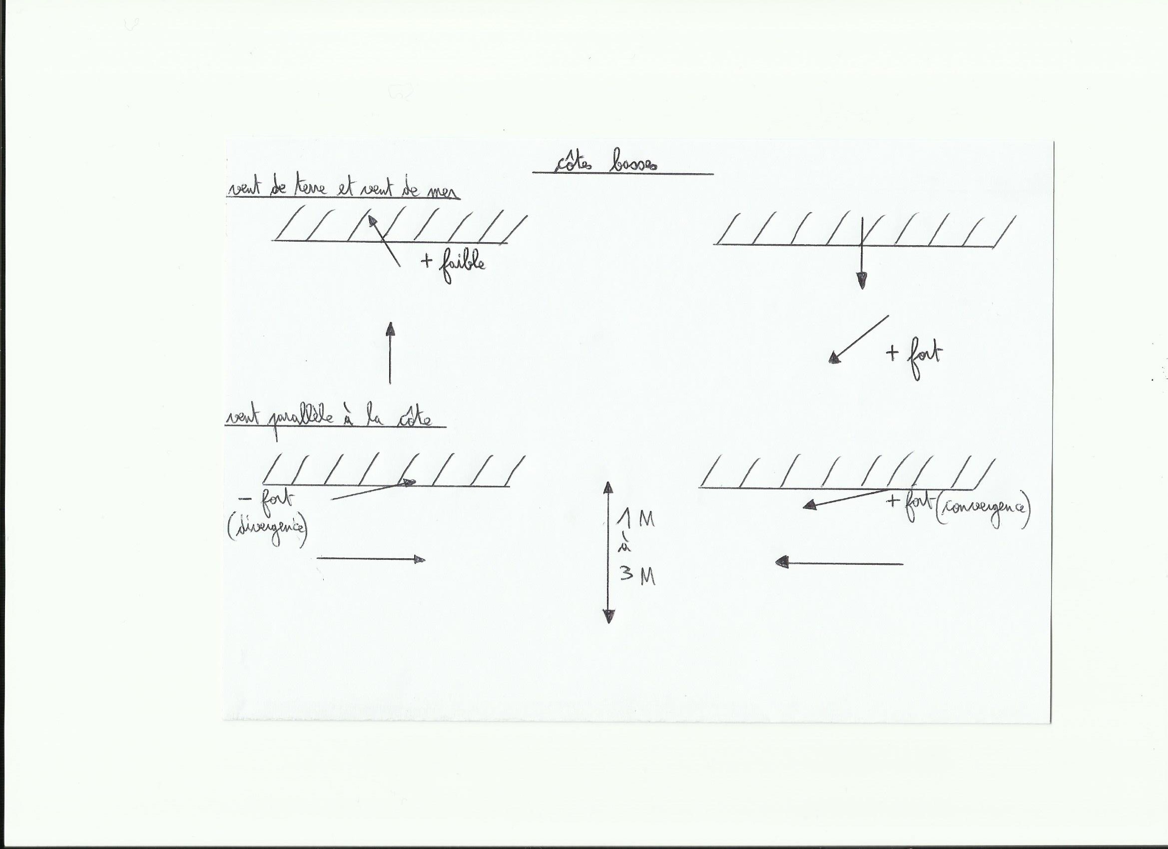
In altitude wind follows the isobaric lines(lines of equal atmospheric pressure)and with the friction on surface, wind enters in LPS forming an angle of approximately 20 ° with the isobaric lines. With a larger friction(On earth with mountains for example)this angle will increase.


A LPS on its side:

depression4


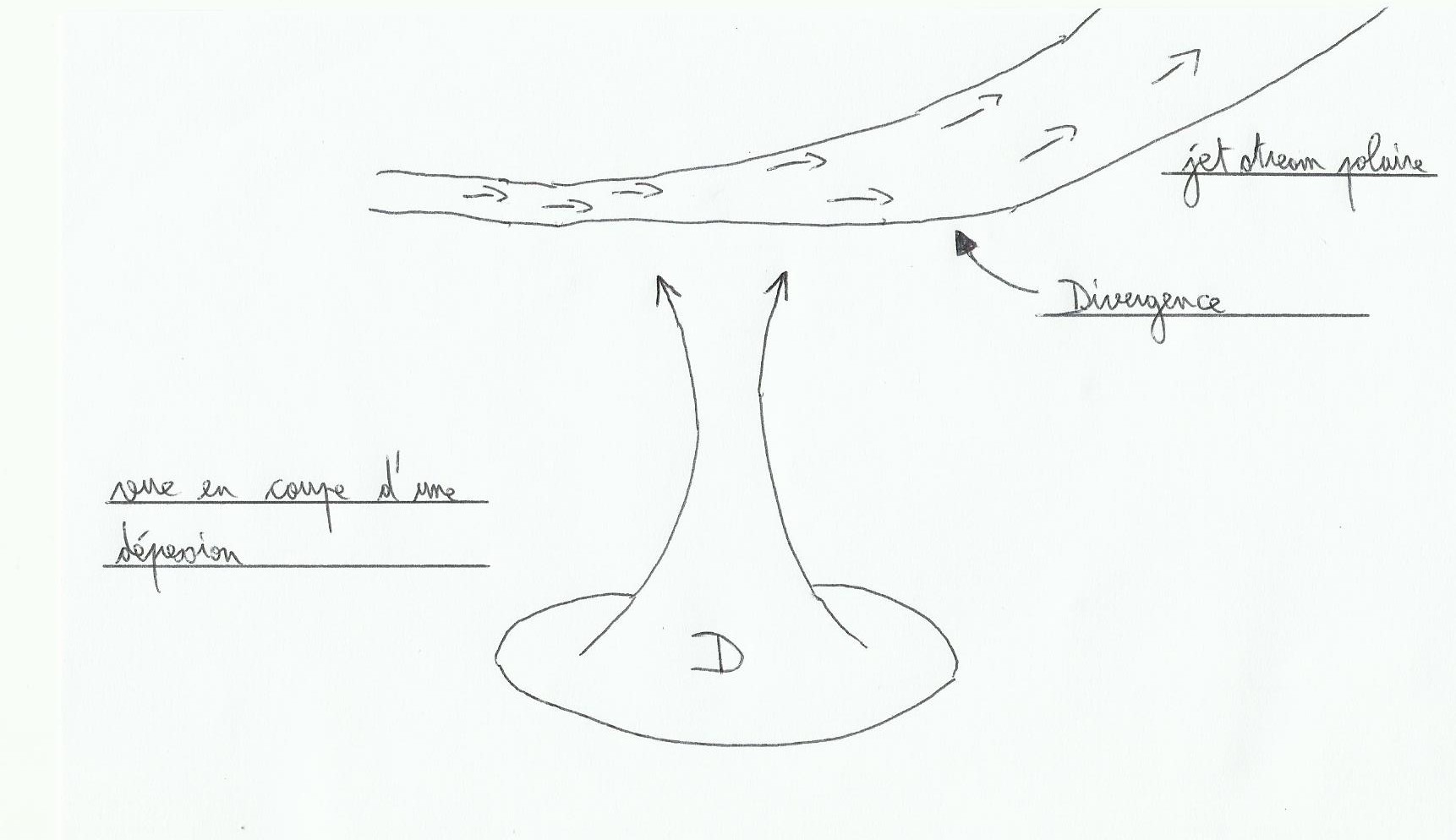
jet stream's divergence creates an air call from the surface.


An another LPS's feature, it is the presence of fronts inside. There are two kinds of fronts, warm front and cold front, and two areas called cold sector and warm sector(because LPS is nothing more than a meeting between a stream of cold air and a stream of hot air under Coriolis influence). For LPS more “matures” we find an occluded front and a triple point too.

depression5

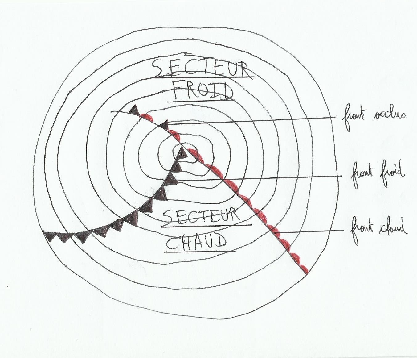
On the weather forecast's maps warm fronts are red and cold fronts are blue(I have lost my blue pen…), they are symbolized like this draw on the right. The triple point is the meeting point of fronts.


When a LPS grows, at the beginning there is no occluded front and warm and cold fronts are wide apart. With time, the cold front (which is fastest) overtakes the warm front creating the occluded front which increases progressively as the warm sector is overtaken, and the triple point is shifted more and more with the center of the depression. The more LPS gets older and more fronts will turn into LPS in the same direction as the wind.

Occluded front: when the cold air mass has overtaken the hot air mass, the lighter warm air was ejected in altitude. These fronts are generally characterized by a very overcast sky and rain, less windy.

Cold front: when cold air ejects warm air aloft, this leads to unstable wind and visibility conditions . This is generally the place where the wind is stronger with presence of squalls in a LPS.

Warm front: Here the warm air rises gently above the cold air, causing a gradual increase in cloud cover.

2)Clouds met

Different types of clouds are found in LPS depending on where you are inside, and the barometer is also a precious tool to locate yourself inside.

depression6

1. Warm front arrival: first we can see cirrus(high clouds with a hair shape, filaments)with a decrease of the atmospheric pressure. With more cirrus “curved” there is more chances to see the situation deteriorate rapidly. For the moment the weather is still clear with good visibility. Followed by cirrostratus(still in altitude), clouds formed by ice particles look like white veins, the only one able to produce a halo around the sun or moon. If halo decreases, it is a sign of rain, Check the warm sector. At this point the pressure is further reduced and the visibility decreases.

2. Warm sector: cloud cover goes down and grow, pressure still decreases. Just before the warm front we see altostratus(greyish veil through which the sun or moon may appear as a blur disk)the sky is darken. The warm front brings stabilization of the atmospheric pressure and a low, dark cloud cover with rain(stratus, nimbostratus). In the warm sector, we find stratus which are the lowest clouds, making a uniform veil; pressure is still stable and visibility is low. Usually in the warm sector winds come from the west or south-west(Northern Hemisphere).

3. Cold front: Cold front arrival brings a slight decrease followed by an increase in atmospheric pressure. cloud cover which is still thick rub out a little, squalls come. At the cold front we notice the cumulonimbus presence(very extensive vertical clouds, source of strong wind and gusts), a rapid rise in pressure and a better visibility however reduced under squalls. At the cold front there is also mostly a wind shift to the Northwest.

3)LPS life

Youth: fronts are setting up, the pressure decreases and the angle between fronts is very wide. LPS center is superimposed with the triple point, rain appears close to the fronts.

Maturity: LPS moves faster(between 15 and 40 knots roughly), the cold front begins to overtake the warm front creating the occluded front, and the triple point separates from the center of the depression. The wind gets stronger under the cold front, and shows a significant changes about wind direction.

Ageing: Significant occlusion with the approach of the coast, LPS center slows or stops. Rainfalls increase under occlusion and the wind is less strong, the wind shift at the cold front is less significant.

End: the fronts are no longer differentiated each other, LPS doesn't move anymore and fronts still turn around LPS center with its heads down.

4)Cross wind rule

This convenient and effective rule is a little asset to locate yourself in a LPS, it provides clues to guess upcoming weather(here, Northern Hemisphere).

You are in face with the surface wind. With altitude winds(indicated by the high clouds, cirrus eg), you may grab clues about LPS motions:

.If the altitude winds are coming from the right, the warm front is coming.

.If they are coming from the left, LPS is going away.

.If surface / altitude winds are parallel, or almost parallels around some degrees of course, and in the same direction we are in the warm sector(but generally in the warm sector we can not see the high clouds, we know that we are here with steady pressure and dense cloud cover, low and rotten…).

.If it's parallel and opposite, you are in the cold sector, LPS north.

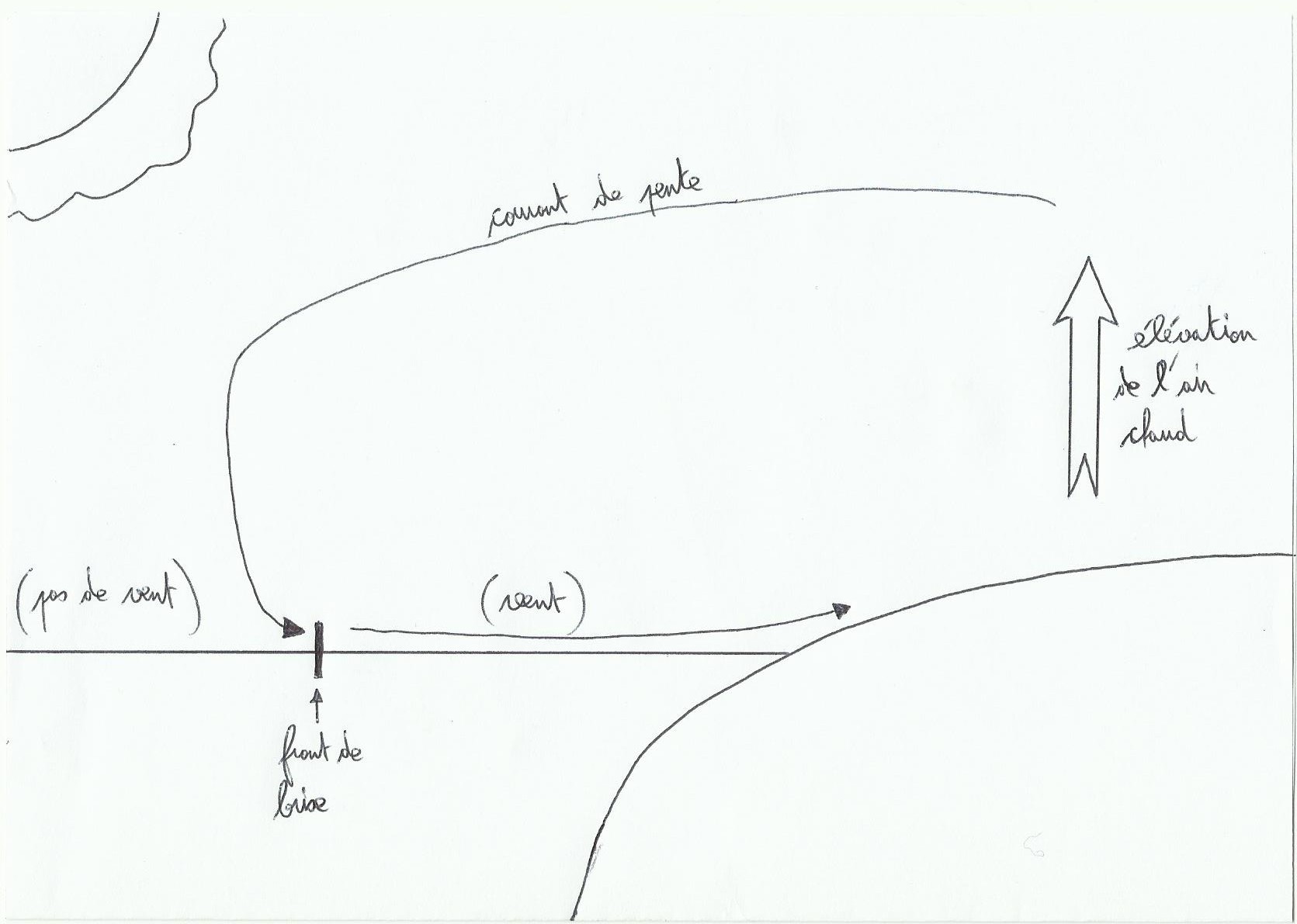
Notice: A west residual swell may also be an another clue for a LPS arrival.

There are plenty of books that explain very well LPS as “weather and strategy, cruising and racing” de Jean-Yves Bernot, navy block is not bad too.

depression-meteorological-by-satellite-iceland-file-cyclone_121-63213


Hurricanes

They are found mostly in the western oceans in their intertropical area. They happen mostly during the late summer(September in the Northern Hemisphere and February / March in the South). In the North Atlantic hurricane season runs from July to November; Hurricanes number may change from year to year. We always give them a female name…

cyclone_vu_de_l_espace_1426

1)Origin

The first stage is the tropical LPS, it requires several points to establish. Sea's temperature should be more than 26 ° C on a depth of 50 meters at least, there must be a low pressure area on the surface. a weak altitude area of ​​high pressure should be there, and the variation of wind between the surface and the altitude must be weak. Hurricane works like a chimney which inhales air from the surface to the high levels, this chimney must not be “cut” by too strong winds along its length. The Coriolis force must be strong enough(below 5 ° of latitude there are less chances to meet a cyclone).

2)How it works

Outskirts air is inhaled to the center of the tropical LPS and move like a spiral with Coriolis(in the northern hemisphere anticlockwise). Close to the ground winds come from all directions and rise, this place is the eye's wall of the hurricane where it is the most violent(into the center it's quiet). Hurricanes, even if they recall the shape of our LPS in temperate areas are different. They are smaller(500 to 1000km in diameter)and they move slower(5 to 15 knots roughly). The diameter of the eye is about fifty kilometers. This phenomenon can not occur on land or cold seas.

3)Some tricks

The dangerous zone during hurricane season is the area with the radius of 24 travel times of the hurricane. You can also divide hurricane in two parts(dangerous semicircle where the wind speed is in addition to the hurricane's wind, and the other half-circle):

cyclone

Hurricanes are classified according to the Saffir-Simpson's scale in 5 steps, hurricane's intensity may grow from 64 knots(only!)in step 1 to at least 136 knots(guys open the Bible and good luck!)in step 5.


The barometer

It's essential to foresee the weather framework, and to locate yourself depending on LPS or an another system(anticyclones, LPS). For a full overview's analysis you must mix informations given by this tool and sky's shape(clouds type, visibility), synoptic wind's direction and sea state, you may also add changes in temperature or humidity. But even alone, it is a needful tool to predict weather and for safety.

1)Atmospheric pressure

The barometer indicates atmospheric pressure in hPa. This pressure depending on air weight on a given point has been discovered by a Galilée's apprentice, Evangelista Torricelli, with his invention of the mercury barometer and inspired by Benedetto Castelli, an another student of Galilée specialized in hydrology. To sum up Torricelli realized that the atmosphere's weight created an almost constant pressure on the surface's earth, and this pressure was in fact quantifiable with fluids, malleable under a force.

we almost find the same thing in scubadiving where pressure increases of one atmosphere's earth every 10 meters roughly(the sea surface pressure is 1 bar, in fact about 1013 hpa, and at 20 meters it is 3 bar, in fact about 3040 hpa) the more we go deep the more water's weight above our heads is strong. Fortunately, air's weight is much less heavy!

Knowing that a mass of warm air is less dense so lighter compared to a cold air mass, less light so “heavy”, you soon realize the barometer's usefulness to anticipate LPS, fronts or anticyclones(decreasing pressure may indicate a warm front coming, increasing pressure, a cold front). In fact if you see the barometer falling it will usually indicate the arrival of a LPS, if it rises it will indicate the arrival of anticyclonic conditions.

Atmospheric pressure can be illustrated with the ideal gas equation:

Pressure(pascals)*Volume(in m3)= Mass(in Kg)*R * Temperature(in Kelvin)

R is the gas constant, R value for dry air is 288 and for water vapor 460 roughly. 0 Kelvin = -273.15 ° C.

2)Barometers types

There are mercury barometers, water barometers, gas barometers(they use a fluid's deformation under pressure to find data). On board we mainly find brass barometers called “aneroid barometers” and electronic instruments that operate with a vacuum capsule's deformation.

Aneroid barometers use a hermetically closed box, empty of air. A membrane fixed on this box moves under pressure and a mechanism transcribes data obtained on a dial with a needle.

3)On board

To adjust a barometer with accuracy, you may catch atmospheric pressure data at the closest harbour's office, and add the following correction:

Correction(hpa)= 0.12 * height difference(in meters)

The height difference is between our barometer and an another used as a reference. If our barometer is lower than the reference barometer correction is added.

Pressure changes more or less fast are very important, on each line written in the logbook we have to write those barometer changes too. The more pressure changes quickly , the more wind may rise in strengh(this is true both for a decreasing or an increasing pressure, main idea is the speed of change).

Under our midlatitudes(about 45 ° of latitude), we may say roughly:

.A change of 5 hpa in 1 hour announces at least 50 knots(well then it's better to put away fishing rods and take a drink to the next pub…).

.A change of 3 hpa in 1 time announces about 40 knots.

.A change of 3 hpa in 3 hours announces about 25 knots.

If we are lower in latitude, for the same rate of pressure changes, there will be more wind; if we are higher in latitude, for the same change there will be less wind. I guess that this is brought by Coriolis which is less powerful when you approach equator.


Some local effects

1)Sea breeze

It's coming from a temperature's difference between the air above the sea and the air above the land. This difference causes a movement of air flow as a small convective cell; the lighter warm air on land will rise , creating a lack of air filled by an air flow coming from the sea.

local effects

Water is slower to warm itself than land's surface as day goes along. The sea breeze begins mainly early in the afternoon when the land has had enough time to warm itself. Breeze always chooses the shortest path to reach, At the beginning often perpendicular to the coast, it turns to the right during the day in easing off(about 5/10 ° per hour)and it's finally parallel and mostly stops early in the evening. Sea breeze is characterized by the presence of cumulus(clouds in pieces of cotton shapes at low altitude) above the coast and not above the water, when those clouds have grown it's a sign that sea breeze will soon stop.

This phenomenon requires a factor's combination to exist: requires a difference significant temperature between land and sea, a synoptic wind below 15 knots, a long sunshine, a clear horizon offshore, a short Coast and a synoptic wind orientation must come roughly from the coast to avoid a break down on the air flow("courant de pente on the graph")("règle des quadrans in French").

2)Squalls

These clouds alter the strength and direction of the synoptic wind on their way, there are two kinds of squalls:

.Squalls without pouring rain

local effects2They work like a vacuum cleaner which inhales surface's air aloft, creating a local wind. Sometimes when we cross a stormy squall offshore, we have a strange view that the squall moves on the opposite direction depending on surface's wind. In fact surface's wind felt is the air pumped up by the squall.

Motions

locaux3 effects

Squall wind added with synoptic wind provides the wind felt in green. The wind is stronger at the top of the grain and lower down on the little draw. In the northern hemisphere squalls move from right to left when we are in face with the synoptic wind(because of less frictions with surface in altitude).

.The wet squalls

locaux4 effects

Unlike squalls without rain, this time we will find more wind down to the squall and less on its top(cf draw).

3)Coast effects

Coastal landforms as we saw at the beginning sometimes changes the synoptic wind with temperature, but its shape also affects.

.For low coast(example south of Brittany)

locaux5 effects

With frictional's forces stronger here the wind turn on the left when it's closer to the coast.

.moderately high coasts

locaux6 effects

When the wind is perpendicular to the coast and just offshore it creates a windless zone called “cushion” near the coast. If it comes from land it also creates a windless zone, the “dévent in french”; the more high the coast will be the more wide this windless zone will be.

For high coasts such as Corsica, differences in altitude change the nature of air masses.

4)Peak effect and Venturi effect

locaux7 effects

Peak effect is felt around the capes, Venturi effect occurs at the mouths(example Morbihan gulf, Gibraltar strait). Those things due to the coastal shape increase synoptic wind strengh.

The Coriolis force

The wind never moves from high pressure to low pressure directly like a straight line, it is deflected because of the rotational movement of earth. The Coriolis force is the result of that motion.

1)In a register mark in 2 dimensions

Motion is a relative concept, it depends on the point of reference of it. We'll take the example of the turnstile seen in funfairs.

coriolis

When Bernard throws the ball to Jacky(please forgive my lack of inspiration for those names, but well…), an observer placed outside the turnstile will see a straight trajectory for the ball's way.

But for Bernard and Jacky, Ball's trajectory will be deflected to the right in a curve's shape(So for everybody placed on the turnstile).

For earth it's almost the same idea, the turnstile symbolizes the rotating earth and ball's way represents wind's displacement(or current). For the southern hemisphere just resume the same pattern by reversing turnstile's rotation, the ball(the wind)will be deviated to the left.

2)In a three-dimensional register mark

The Coriolis force depends on three things: the mass of the moving body, its speed and its latitude. It can be written in that sentence:

Fc=2*m*(speed vector* angular speed vector)

The angular speed is the rotational earth speed(roughly 15 degrees per hour). Note that this equation mentions a vectors multiplication, to find vector's norm obtained the calculation is:

||speed vector||*||angular speed vector||*sin(L)

L is the moving thing(wind or current)'s latitude.

coriolis 2Notice: as the sine function is symmetrical relative to the point 0( in a Cartesian coordinating system)then we can deduce that the more the object is close to the latitude 0, the more Coriolis force decreases until it becomes zero at the equator. On the contrary, Coriolis force is strongest next to the poles.


There is a good illustration of this phenomenon with Foucault's pendulum(the first experiment had happened in the pantheon, there is one in Paris that runs continuously since 1995 I think…). I will do a little thing on it later it's pretty funny(we may guess our latitude depending on pendulum rotation speed).


Main things…

Earth's atmosphere is divided in several layers, one of them will concern us particularly for the weather things: the Troposphere. It ranges in altitude up to fifteen kilometers at the equator to its maximum, and it is the main action's playground for weather. The troposphere's boundary is called tropopause.

1)The wind

Air is a very poor conductor of heat, Uneven atmosphere's warming on earth will create warm air and cold air currents. These currents will move and act on the weather differently. Warm currents, less dense so lighter, will tend to “rise” Unlike cold currents, more dense so heavier. limits between those currents will create things that we call fronts. Wind is the result of an exchange between these air masses.

2)The main systems

In our middle temperate latitudes the weather is organized around two main systems: high pressure systems(anticyclone) and low pressure systems. Anticyclones correspond to dense air masses, dry and cold, relatively stationary, and LPS warm air masses and rather humid, relatively moving. Whatever hemisphere, air always goes from high pressures(so high pressure systems)to low pressures(Low pressure systems).

3)Basic laws

.Buys-ballot rule: In the northern hemisphere when we are in face with the wind, we have low pressures on his right. In the southern hemisphere it's the opposite. To summarize in the northern hemisphere the wind rotates anticlockwise around LPS, and clockwise around HPS(it is the opposite for the southern hemisphere).

.Coriolis Force: It's due to the earth rotational motions. It deviates to the right movements of large masses(winds and ocean currents)in the northern hemisphere and on the left in the southern hemisphere.